Portage Glacier and . . .

We passed through Anchorage with a couple of stops for traffic lights and out onto the Seward Highway headed along Turnagain Arm towards Seward.  We made many stops along the way to see the scenery and to view Dall Sheep on the cliffs above the highway.  We stopped at the Girdwood Tesoro Station to top off fuel since there is no fuel for the next 87 miles and it will be much more expensive in Seward than in Girdwood (90 miles from the nearest gas station).  We also topped off propane and emptied our holding tanks in preparation for dry camping in the Portage Glacier NFS campgrounds.  The short of it is we spent two nights in the NFS campground at $9 a night and then moved across the road to a NFS dispersed camping area, free.  I like that better since the services are the same and we shared the space with one other Escapee couple.  The Tesoro station was a zoo.  there were cars, RVs, and boats on trailers in every conceivable place and some places that weren’t.  Oh yes it was Father’s Day and they were almost all Alaskans returning from the weekend camping, fishing, biking and any other outdoor activity you can think of. 

Monday we set out to see Whittier which meant driving through the only tunnel that shares space with trains.  The tunnel was built as a train tunnel and in 2000 they remodeled it and added pavement so one lane of car traffic can use the tunnel when there is no train in it.  On the hour, for 15 minutes you can drive to Whittier and on the half hour, for 15 minutes, you can drive back.  In the car it cost $12 to go to Whittier, no charge for the return.   The history is fascinating.  It was created in World War II as a secret harbor.  In order to use it they had to cut the tunnel though the mountain.  For more than I choose to write follow this link.  We spent two hours in the museum and wandered the waterfront.  We chose not to take a 26 glacier and animal watch cruise at this time.  Instead we returned to the coach for lunch and then drove up the road to Girdwood.

We had a coupon for a free ride up the Alyeska Ariel Tram for one.  Then we learned that if you climbed the mountain you could ride down compliments of the resort.  We set out to climb the 2,000 feet to the tram house.  Yes 2,000 feet in 2 or 3 miles depending on the route.  The trail maps were not wonderful, especially since there were no sign posts at trail intersections for hikers, there were plenty of signs for descending skiers and even some for descending downhill bikers (suicidal maniacs).  We climbed and  climbed and everyone we met climbing down said just keep going up, you can’t miss it, all roads lead to the tram house.  After a couple of false starts at the foot of the chairlift to the very top from an upper bowl we found ourselves on a narrow trail that does not look skiable along side a chair lift with no indication other than a windsock that we might be anywhere near the top.  I pulled out the map one more time and found the phone number for the lodge and was rapidly routed to Brian who knows the mountain.  I described what I could see and and told me exactly where we were and that we were only five minutes from the top.  Maybe for him five minutes.  By then I was on my last energy, Carol was ready to hop and skip to the top.  Fifteen minutes later we emerged at the tram house and headed for 7 Glaciers Inn.  Yup you can easily see 7 glaciers from there. 

To make a long story longer, as we entered the bar of this very swanky resort in our climbing togs with backpack and trekking sticks, we saw another couple who seemed to be alone looking for an appropriate place to sit.  I said “join us” and they did.  Ann and Bill are younger than us and they had flown to Alaska to celebrate Ann’s round number birthday.  As we ordered we revealed that we were celebrating our 47th wedding anniversary a day early.  We decided to drink to celebrations and had a delightful time.  They left to make a phone call and we decided to dine right there since it was already 7 and the only other place we had a recommendation for was closed on Monday.  It was the right choice.  Highly recommended if you don’t mind prices that are high by Alaskan standards. 

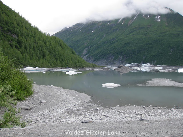
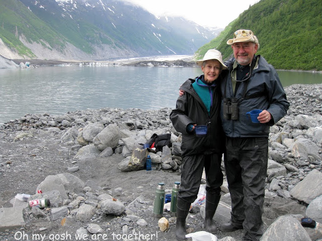
Tuesday morning, our anniversary, we moved the coach across the highway to dispersed camping area where there is no charge, my favorite price.  As noted the only other coach there was Mark and his wife, Escapees who have spent the year in Alaska.  We won’t do that, although the place does lead one to consider it, the cold and snow make Rochester look mild.  After setting up, we set out for a hike to Byron Glacier.  At the trail head there was a sign that there would be a hike with a Ranger and a licensed ice worm hunt.  We changed plans, picked up lunch at the coach and went to take a ride on the MV Ptarmigan to actually see Portage Glacier.   We returned to the trailhead and met up with the Range and a “Jr Ranger” 9 year old and off  on to the trail and on to the snow pack below the foot of the glacier.  I will include copies of our Ice Worm “Hunting License” when the connection is better.  I could not get a picture of the one ice worm the Jr Ranger found because it is really hard to photograph an item one inch long and the diameter of a course human hair being held on snow in the palm of someone’s hand.

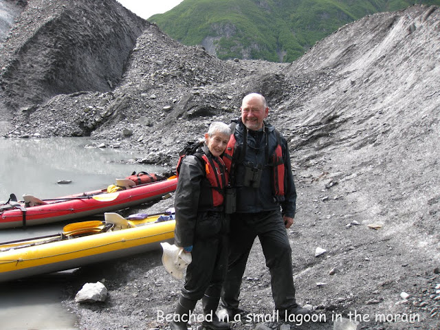
Next day we moved on to Seward.  Tried to stop on the road to Exit Glacier, but most of the free spots were taken and even those do not appear to be suitable for us.  So much for free.  We are staying in Resurrection CG – Seward City Park.  Not hooked up but we are directly on Resurrection Bay, 50 feet give or take from the water, depending on the tide.  So far we have taken another glacier, wildlife tour with Major Tours, done a Behind the Scenes tour of the Alaska Sea Life Aquarium, wandered all through Seward on foot, ridden our bikes out to the end of road at Lowell Point to book a kayak trip with Millers Landing.  We took the kayak trip yesterday, the paddle was seven miles on the bay, planned paddling  time was  2 1/2 hours.  We grounded short of two hours and the hike to the WW II fortification took less than an hour.  All in all we had about 30 minutes to explore beyond the time scheduled. 

Although we have pictures of all these activities, my current Verizon connection is not good enough to upload the images.  I will post a bunch of them to my web album as soon as I have a decent connection.

We Meet the Nicest People

Our travels have always been about people and places.  We certainly have the good fortune to sit next to interesting people in restaurants, in campgrounds, standing in line for almost anything.  The places are there for the driving and looking the people sometimes require some effort on our part.  Read on.

We reluctantly pulled out of Chena RV in Valdez leaving the most wonderful owner/operators we have run into.  Judy was there to greet us in the morning with suggestions to make our day better and to welcome us back in the evening with questions about how we enjoyed our activities of the day.  She and her husband are very solicitous and go out of their way to make RVers feel welcome.  Wash the coach? by all means use as much water as you need.  TV? here is the included cable and a decoder box.  Wifi, included and a good strong signal with a fast connection to the internet (backhaul – as the techs say). 

We drove back up the Richardson Highway, the only road in and out of Valdez, over the Thompson Pass, stopping at Worthington Glacier to walk out and take a look at it.  We pulled into Copper Center, which is on a loop road off of a loop of Old Richardson Highway off the highway, got that?  We did not eat at the roadhouse, mostly because we had just had lunch and weren’t planning to spend the night there.  After an hour or so of poking around, we headed up the road a few miles to the Wrangell-St Elias National Park and Preserve Visitor Center (I will not spell that out a gain).  As promised in our Days End subscription, an Escapee Only source, there is a double ended pull out with signs on the side road to the Visitor Center, just outside its gates.  There are no signs forbidding over night parking, which in Alaska, we are told, means it is permitted.  We went into the center and talked with the rangers, one of whom seems a bit rigid and questioned the propriety of such use of the pull out but agreed that so long as it isn’t signed there was nothing she could do about it.  After watching the film about the park we bought two copies for distribution to our children and beyond, just to make them envious!  Then we drove out to the pull out and set ourselves up for dinner and the night.

It seemed that Palmer was to be our next stop as I had our mail sent there for pickup at General Delivery.  We did not know when it would arrive and really did not want to pay for a campground.  I got out the Days End section for Alaska which I have printed out, and checked on Palmer.  The only Escapees in Alaska who offer overnight stopping are the Mathews in Palmer.  We called and were welcomed warmly.  On arrival Dave was out in the yard to show us where to set up.  He courteously let me ground guide Carol into backing into a fairly tight spot.  After a brief tour of Palmer during which we found our mail waiting for us we returned and brought a bottle of wine and some dip into the house for Happy Hour.  It is great to make new friends. They are very attentive and when we started talking about what to see in Palmer Dave reopened his memories of being a volunteer in the visitor center and gave way too much to do in a day.  The next morning he greeted me with a list of all the must see and do things from Palmer down through Anchorage and the Kenai Peninsula. 

Short history course.  There was a depression in the 30’s.   One attempt to alleviate the troubles was a program of colonization of empty areas.  200 families from Upper Michigan, Minnesota, Wisconsin and one family from Oklahoma were transported to Palmer Alaska in 1935.  Some 60% did not take advantage of the return ticket that was available.  All of the construction was done by imported workers to plans drawn in Washington.  Some of the designs fell a bit short, the barns are too small for their intended use as dairy barns.  This is a surprisingly rich agricultural area and there are dairies, hay farms and vegetable farms thriving in Palmer. 

There is also a Musk Ox  (they have no musk and are not oxen being most closely related to goats) farm that sells the combed out under hair of the musk oxen which is shed in the spring to a native coop that weaves the most gorgeous pieces from the spun yarn.  It is very warm and very strong and oh yes VERY expensive.  The participating natives are able to stay in their villages up near the arctic circle and continue their culture and life style thanks to the cash they earn from weaving these scarves and other articles of clothing.

Oh yes the other thing they are trying to do is to domesticate the musk oxen.  The first new animal to be domesticated in 1,000 years.  They expect the project to take a total of 250 years.  193 to go.  The first place these animals were raised on a farm was in Vermont.

Have I run on enough?  Nope.  From the Musk Ox farm we drove up Hatch Pass to Independence Gold Mine state Park at the top of the pass.  They started serious hard rock mining there in 1937.  Production peaked in 1941 and 1942 brought orders to shut down as gold was not military necessity and the resources they were using needed to be redeployed.  They struggled to keep the mine open claiming they could produce a precursor to tungsten, but the ore was of such poor grade that they never shipped an ounce.  By  1943 the site had been abandoned.  The mill works have collapsed and only the living quarters remain intact.  The tour was great fun and the area is wide open for exploration.  the weather was superb and it being Saturday Alaskans were out in force hiking and sunning where ever we looked.  We finally returned to the coach to a quiet dinner and a chance to record this.

To see all the pictures from this trip Click Here The pictures from this blog are near the end.

Onward to the Kenai Peninsula tomorrow.

Valdez

We took our time driving from Chitna to Valdez.  After looking at all the possibilities we decided to stay ion town at a very small RV park called Chena.  It appealed to us because it had only ten sites and the Churches did say the owners were very helpful.  On our way in we drove by half the other places and our choice was confirmed.  Instead of 160 sites on a sea of gravel Chena has just eh ten sites on a pond of gravel.  Gravel makes sense here as it does not become mud or snad to track into the coach and water drains right through it, no standing puddles to breed mosquitoes, there are enough of them as it is.

The drive took us over Thompson Pass at 2,800 feet.  It does not seem very high, but it is clear the weather in the pass can be fearsome.  We have been told by locals that the plow crews use GPS to guide them through the pass in storms!  We came over it in clear weather.  We passed the turn off for the old town site which was devastated in the earthquake of 1964 and continued into the town that was rebuilt and has grown with the routing of the Alyeska Pipeline to the port.  It is a great fishery and we have seen halibut over five feet long hanging from the catch racks of the charter companies.  I bought some an grilled it.  I am reminded of Talkeetna, 1997, my most memorable halibut meal, eaten at a picnic table on the curb there. 

We took a cruise with Stan Stephens to Meade Glacier which included poking in as close as we could get to Columbia and Shoup glaciers and some whale watching and sea otter watching and Dall Porpoise watching and bald eagles and puffin, both horned and tufted and bear watching.  We saw one bear swim across from the mainland to an island as we were traversing the passage.  Stan said he had not seen a bear take that long a swim in his time here – he is in his 70’s and has been guiding in Alaska 50 years.  Here are some pictures from the day trip:


Plans to go sea kayaking have been placed on hold, not enough people want to take the trip we want to take for it to go. We decided to take a “domestic day.”  Many chores great and small have piled up.  Carol did laundry while I washed the coach down to remove the sand and road dirt from our drive over TOW and down to Chitna.  Our neighbor works at the local NAPA store and he located a replacement for the oil filler cap I left back in the Yukon someplace.  We still have piles of dust and grit in our storage bins, but that will just have to accumulate until we get on paved roads in the lower 48.  We did wander around the harbor area and walked into Anadyr Sea kayaking.  We had not walked in there before.  they offer a kayak trip to Valdez Glacier which involves a four or five mile drive rather than a two our boat ride to the kayaking site.  WE sgned up for the next day.

We met Heather, the guide, and David and Joanie whose son works on a fishing boat in Valdez for the summer.  The five of us set out for Valdez Glacier with full coverage rain gear over long johns and fleece for warmth along with PFDs (Personal Flotation Device) for safety.  We put into the water with the hope of entering an ice cave or two, walking on the glacier and maybe seeing some other interesting feature.  As with wild life viewing there can be no promises since the features of the glacier change from  day to day as the weather and glacial movements shift things around.  Rather than give you a blow by blow here are a selection of pictures from the day:

And there you have two days in Valdez with more to come.

An Unplanned Day

Not that we ever stick to a plan, but today, Thursday June 9, was particularly fragmented.  For starters we had decided to head for Valdez instead of Fairbanks.  A couple of days ago I decided it was time to have a steak so I had pulled one out of the freezer to keep in the refrigerator.  We are traveling alone because other than some dear friends we find it best to keep to ourselves.

As we rolled down the Tok Cutoff toward the intersection with the Richardson Highway which would take us to Valdez I was reading in The Milepost about some other places to see along the way.  I saw that Copper Village looked like and interesting stop and a mere 35 miles out of our way was Chitina at the end of a 35 mile in and out road.  It seemed reasonable to take that side road, especially after checking my other resources and finding that there is Federal land that is available for “informal” camping.  That means pick yourself a piece of land, set up camp and enjoy.  No rules, no fees oh and no supervision.  As it happens this piece of land is located at the junction of the Chitina and Copper Rivers and is the only place in Alaska where dip netting and fish wheels are permitted. 

As I began to learn this we pulled into an overlook and met Stan and, and oh well both of us forgot her name.  We shared the thoughts and they thought they might join us.  We passed each other several times along the road but somehow we are in  Chitina and they are not nearby.  I already described the Top of the World Highway.  This route was not quite as bad, we averaged well over 30 mph while moving.  This does not include a 20 minute halt on the road for construction vehicles to move and many stops to ooh and ahh.  Finally we made it to the Wrangle Elias National Park Visitor Center, which is not in the park because the only access to the park is over really interesting roads, by plane or boat.  We heard a presentation on Wolves by a summer Ranger, nicely done, nothing particularly new, and we drove on.

We drove on slowly as the road continued to alternate potholes (Rochester you ain’t seen nothin’) with frost heaves – think of a giant economy sized speed bump with sharp sides – with whoop-de-dos, sort of like the road falls out from under you and just as you are dropping it rises to boost you into the air.  They are more exciting when they are at an angle across the road so you twist as you bound.  Opening a cupboard after a day of this can be life threatening. 

Anyhow we descended into Chitina and passed through the town and out the other side, onto the McCarthy Road and over the Bridge to the “informal” camping area. 

We decided to camp well away from the area of active dip netters as we did not want to be seen as interfering, especially as they are expected to here in force tomorrow.  Many of them have set up fish wheels.  

These scoop the salmon out of the water and shunt them in live catch wells where they wait to be filleted.  Carol and I got talking to a couple of men working together filleting fish after fish.  they had already filleted 28 fish that day – apparently there is no limit here.  As we asked questions and responded to theirs, the man doing the filleting motioned to his buddy to get a small fish out of the well and then he stunned me by asking if I wanted it whole or filleted.  After asking twice to be sure I had understood the questioned he filleted the fish before our eyes and bagged it and gave it to me with instructions not to overcook it.  Color me flabbergasted. 

The steak stayed in the refrigerator for another day while I grilled one fillet to eat half

and save the cooked part for another day.  The other fillet went into the freezer.  the net weight of fresh Copper Red King Salmon minutes out of the water was over 2 pounds.  Retail price is incalculable (well I saw it for $7.50 a pound today) and I must say taking a fish and putting it on the grill within minutes of its coming out of the water is beyond compare.

Yet another unplanned day!

Friday we decided to try the drive to McCarthy on the McCarthy road, a 55 mile drive on a dirt and gravel road reported to be a very difficult road with old railroad spikes just waiting to eat a tire, the road is laid out over an old rail bed.   The drive to McCarthy was fairly straight forward, it took 2 hours running at speeds up to 40 and a lot of 20 and 30 mph stretches. After Top of the World it was a piece of cake.  We had the bikes on the roof and I had brought along the seats and other paraphernalia necessary for bike riding.  When we got to the end of the McCarthy Road we were confronted with a foot bridge and a half a mile walk beyond that to get to McCarthy, or hiring a shuttle from the other side of the footbridge.  We got the bikes down and with much trepidation, put them together.  We had not ridden them in several months (we actually can’t remember the last time we rode them), the chains are rusty and everything was a bit stiff.  The tires were soft as well and I had not thought to bring my pump.  That was good actually as the road was dirt and lent itself to underinflated tires. 

We reached McCarthy and discovered there is not anything to do there before 5 PM, and it was not yet noon, except go on to Kennicott to tour the Kennecott Mine Mill and the Kennicott glacier.  Those are not my misspellings.  They meant to name the company after the glacier and misspelled it. 
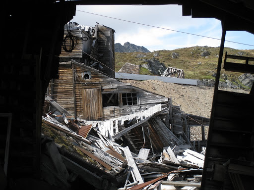
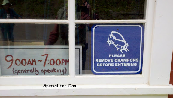
We chained up the bikes and took the shuttle to Kennicott where booked the tour and went to Kennicott Glacier Lodge for a lovely lunch while waiting for the tour.  Here is the mill: Looking up at the 14 story structure from below knowing that it was built in 1908 we did not expect the tour to us take all the way through the remaining interior portions.  We indeed climbed to the very top where copper ore was received from the mines by tramway and followed the processing all the way to the very bottom where the finest poorest grade ore was sent to the leach plant for further extraction. 

The road we had driven was on the rail bed of the line built to haul the coal to Valdez where it was transshipped to Tacoma for smelting.  This is where Kennecott Corp got its start.  It is said they mined enough silver as a byproduct to pay for the railroad, mine equipment and the town, some $30 million and netted a profit of $100 million on the copper.  This is 1930 dollars!

Before we drove up the road to Chitna I had only the vaguest notion of what was here.  The activities we did not partake in included ice climbing, mountain hiking, white water rafting/kayaking, choose up sides softball in McCarthy, or getting drunk in any of the saloons in each of these towns.

On from Whitehorse to Dawson City and Over the Top of the World Highway to Tok AK

Well there was an overnight along the way at Pelly Crossing.  You could look it up someplace I guess, but there isn’t much there, there.  The Pelly is a river that is tributary to the Yukon  and the crossing is a bridge and a small community consisting of a roadhouse and a Heritage Museum to record the local First Nation tribe’s lifestyle and culture.  There is/was a campground across the way.  The reason for the lack of positive description is that this appears to have been a government campground recently, but is currently listed in the guide books as free.  The campsites are “indistinct” and there are no services offered.  This is a better deal than some similar campgrounds that collect $12 C for the privilege.

I have not recorded the long drive we took to get to this halfway point on the road to Dawson City.  It is “miles and miles of miles and miles” to quote an unknown source.  Every turn brings another vista and another ooh and ah and the hope of seeing some wildlife, mostly forlorn.   Rising in the morning to the sound of construction on the bridge we prepared breakfast and rolled on down the road leaving Marty and Nancy, Alaskans who got to the park shortly before us on their trek south, as we continued north.  Sunday was another day of miles and miles bringing us into Dawson City early afternoon.  We decided to stay at Bonanza Gold RV Park just out of town and across the street from Bonanza Gold Service area.  Is there a theme there?  We had rolled up 5400 miles since leaving El Paso, TX !! and it was time for an oil change and other routine maintenance as we prepare for the worst roads of the trip.   Already in the last stretch the road was deteriorating the closer we got to Dawson.

Some highlights of the visit to Dawson include a visit to Diamond Tooth Gerties Casino with three shows a night.  I broke even at the black jack table and got to take a garter off a dancer (you will have to ask Carol to tell you the story).  After the 10:30 show we drove up to Dome which is a five mile drive to a high point above Dawson where the sun barely sets on the solstice.  We did not stay long enough to see it set on June 6.  As I write it is 10:10 PM and the sun streaming in the windshield is almost blinding me.  Our second day, we started out at Dredge #4, the largest surviving dredge from the gold era here.   It last produced gold in 1959.  It is amazing to see the size of this machine.  Each bucket picked up 16 cubic yards of rock to process through the screens.  The most amazing part of the story is that the entire operation was  electric.  They ran hydro power from the Klondike river over more than thirty miles of wilderness to run the dredge.  Since the dredge moved itself up the creek bed they had to continually extend the lines.  It only moved 10 feet every few days so they could keep up with it.  Following the dredge we toured several homes (Jack London’s and Robert Service’s) and then came back for lunch so we could move Gee2 to the service station while we went to town for a walking tour with weird stories about people and places. 

We have had a quiet dinner on the coach and got to talk with Ron and Aiko and Brian and Ruth who we met back in Whitehorse.  Not so early to bed and up sort of early tomorrow to take the ferry to the beginning of the Top Of the World Highway which leads to Chicken and on to Tok.  I hope to post this soon, but even if I get connected in Dawson I will not be able to post pictures.  The band width reminds me of the 300 baud days.  There is only one circuit for the population and it is not fiber.  Anyone uploading video will take down the entire town.

Wednesday Night – it is hard to call it night when you never see dark.

We set out early, for us, at 8:30 AM to board the Black Ferry for a 15 minute ride across the Yukon to drive the road that causes more talk among RVers in Alaska then any other.  It is paved part of the way, it is chip sealed and that has washed away in parts, it is dirt or it is gravel and there is 180 miles of it climbing and descending to live up to its name, Top Of the World Highway affectionately known as TOW.  Carol was at the wheel for the first two hours bringing us to the most northerly land entry into the US at Poker Creek, AK.  By then we had stone chips in the windshield of the RAV4 which was new in LA and there were stones all over the car.  The coach was filled with dust and we still had 120 miles to go.  We covered the windshield with a tarp in an attempt to prevent further damage and I took the wheel just 5 miles before the border.  According to reports we were entering on the worst of the worst road.  Fortunately it had not rained for a couple of days and the road was dry and merely dirt.  An aside to those who know the road to Dan and Malena’s house back in the woods of Virginia, just like that for 60 miles!  And just as narrow with trucks and tour buses (well only one tour bus and no big trucks while we were out there) going both ways.  The one tour bus we encountered had a pilot vehicle out ahead and he radioed back to the bus to wait at a wide spot while we proceeded through the well packed dual track road. 

Naturally we stopped at Chicken.  Think of a bad chicken joke, any bad chicken joke, you will find it there on a T shirt, mug etc.  Susan Wiren, who has been in National Geographic and is featured in the Church book Camping in Alaska, is a true Alaska character.  I will get pictures up on the website when I have some time.  Carol has a new T shirt as do I and I finally got to add a hat to my collection. 

About 30 miles out of Chicken the road improved enough for us to pick up the speed to 40 and even 50 for a mile or two.  180 miles is a really long day when the overall moving average is 30.9 MPH. 

Shortly before Chicken we noted that the sky was misty, then we noticed the smell of fire.  For long stretches our view of the  mountains was obscured by smoke from fires burning a couple of hundred miles to our north outside of Fairbanks.  When we got to the Tok visitor center, they confirmed the presence of many fires between Tok and Fairbanks.  Although no roads are closed, we are thinking that we will head south first before going to Fairbanks.  So as of this writing we are going to head down to Valdez and then over to Anchorage.  It does not change our mileage at all.  If you look at an Alaska road map, you will see that to get from Fairbanks to Anchorage and to get in and out of Alaska by road you WILL pass through Tok.  Tok is Alaska Main Street.  We are comfortably camped behind the Chevron Station which provides free dry camping on their lot for the price of a fill up which we needed anyhow.

Whitehorse Days

Thursday, first day in Whitehorse, we drove in from Carcross then we spent time getting caught up on internet time and other work around the coach like a complete pressure wash.  Then into town to the Visitor Center then on to get Free Parking Permit (closed at 4:30 we arrived at 4:31).  Stopped by the box office for “Frantic Follies” and bought our tickets.  Back to G2 for dinner and then into town for the 8 PM door opening and the 8:30 curtain.  Fantastic show! Definitely worth the price of admission, many belly laughs and endless chuckles. Got out at 10:15 and the sun was still up.

Friday, second day.  We drove into town to see the Beringia Museum (pronounce that with a soft g) which focuses on the prehistory of The Yukon and the many wooly mammoths and similar animals whose remains have been found here (many look much like what has been unearthed at La Brea Tar Pits in Los Angeles).  We arrived there at 9:55 Am in time to see the first of two movies and there was one other couple in the place.  By the time we had played with the atlatl out in the grounds another couple had arrived to join for the second movie.  Then we finally got around to buying our tickets and had a guided talk by the staff person.  At noon we left with the first couple and walked over to the Yukon Transportation Museum which was included in our ticket price.  That museum has photos from the early days of flight in The Yukon, a history of the White Pass and Yukon River (WP&YR) rail construction from Skagway to White Horse and an entire section devoted to equipment used to construct the Alaska Highway.  It was now 1:45 and we went back to the coach for lunch and then roared on.  Next stop the McBride Museum which has collections of material from the growth of Whitehorse with a particular emphasis on the characters.  For our newspaper friends I spotted this, hope you can read it: 

They have the original cabin of Sam McGee (read Robert Service “The Cremation of Sam McGee).  None of the poem is based on fact and Sam McGee actually lived well beyond the time of the poem and in warmer climes, but he was a friend of Robert Service.  From there we went on to the 4 PM guided tour of Klondike the last stern wheeler from the era preceding the highway from Whitehorse to Dawson City. 

There are more pictures on the picasa website, just click on any of these to get there.  Or Click Here

Not done yet!  We drove out Miles Canyon Road to see the Miles Canyon suspension bridge, a foot bridge over this rugged canyon which carries the Yukon River over rapids into Whitehorse.  From there we continued a bit south to Copper Moon Gallery.  Watch for signs otherwise you would have a hard time finding it.  It is an extensive gallery of local artists work.  Although it is uneven, it does seem to feature some of the finest local art we have seen.  This is well worth a stop, about 15 miles south of Whitehorse just north of the Petrogas station (within sight).

Following this we went back to Whitehorse and after a bit of car touring settled on the Bar and Grill at Edgewater Hotel for dinner.  The meals were excellent and we met an engaging couple who collect countries like we collect states and provinces.  They were on the return leg of a car trip from Los Angeles to Alaska. 

End Day 2.  I’m tired!  Not sure what we will do for an encore tomorrow.  I had intended this to be just a list of activities, but I hesitate to fill it out with any more detail.  You will have to make this trip for yourselves!  We know there were 8 tour buses in town, but we managed to miss the crowds where ever we went.

Days 3 and 4 and 5 . . .

After leaving Fort Nelson we made a planned stop at Liard Hot Springs.  This is a well reported “must” stop along the AH (reference to Alaska Highway hereafter).  Unlike the Radium Hot Springs these have not been “bottled” into swimming pools to serve the masses.  The spring descends through a series of pools created by modest damming with logs.  The board walk to the pools and around them is a substantial, but plain boardwalk and the changing rooms are Spartan to say the least. 2011-05-30_12-42-11_812 We entered the water at turned out to be the midpoint of its temperature range.  Moving up stream a few feet raised the surface water temperature a few degrees and a like move downstream lowered the temperature a bit.  The surface water is hotter than the bottom water so if it felt too hot I could just reach down and circulate the deeper water up to mix with the surface to moderate the temperature.  Although I had no thermometer with me the temperature was reported variously as 108 to 110 F.  To other travelers along the way:  This is indeed a must stop and if we pass this way headed south we will stop again.

Although we made several more stops to ooh and ah over the vistas and to acknowledge bison, bear and other critters along the road we eased in to Watson Lake, YT late afternoon and set up camp at Downtown RV.  This was as described a large gravel parking lot with hookups and right in the center of town. 
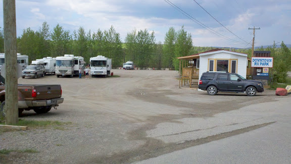
During the day’s drive we had noticed a clanging, banging noise which turned out to be a loose part on a rear wheel cover.  Three of four rivets had come loose and the center section was wobbling and clattering.  I spoke to the campground owner who directed me to the Home Hardware which was through the Signpost Forest and across the highway.  There Homer guided me to the correct bin of nuts and bolts and advised me to add some Loktite to make sure they would hold.  Returning to the campground I set up my repair shop – tool kit next to chair in the sun in front of the coach to make my repair.  This attracted a neighbor who we joined later to see the Northern Lights Show.  Yeah, I know we are in the Land of The Northern Lights, but they are hard to see when the sun has not set at 10 PM and rises before we awake at 4 AM.  So we had to see the video of the Northern Lights in a very nice planetarium facility across the street form the campground.

The next day, as we were rolling toward White Horse, we decided to take a side trip recommended by several people.  At Jake’s Corner we turned down route 8, The Tagish Highway toward Carcross.  Yes, there is a crossing there, but it is not cars.  It is a Caribou Crossing.  After much fiddling around and struggling to find the visitor center we were guided to the Carcross Campground.  The signs we had passed seemed to lead us to driving down the local airstrip, not generally a good idea.  It turns out the road to the campground is maybe 100 yards off the centerline of the strip and then disappears into the woods.  Here we set up camp for two nights with no electric, water or sewer.  There is phone service.  There were only two others in the campground for the night.

Our visit to Carcross included a walk in the Carcross Desert.  A one square mile of dunes left over from prehistoric times. It really isn’t technically desert as it is too humid. It is quite strange to see lush conifer stands in what appears on the surface to be desert and no cactus to be seen, they would never survive the sub zero (Fahrenheit) temperatures of winter.   The town itself is torn up, as the roads are being realigned to make it easier for tour buses to drive through and stop.  Also many of the important structures from times long gone are being restored.  This is not a preserve area so major restoration is more a matter of money than permits.  Walking around in some respects was like walking though a Disney back set before the place is ready for guests.

Day 5, Wednesday, we set off early in the morning (for us) in the car to drive 65 miles to Skagway, one of the premier cruise ship stops on the inland passage.    Before we got very far out of Carcross we spotted two bears on the side of the road sparring.  They were distracted enough that I was able to back the car up a 100 yards or so after going passed them and stop on the side of the road across from them and spend several minutes photographing for me and for Carol.  We signaled to another car what we were seeing and as they stopped we drove on.   The rest of the trip was engaged in much oohing and aahing over the incredible scenery and mountains still enrobed in snow and ice.  We climbed past the Canadian customs, 7 miles from the border and ascended to the border with the US and then descended 7 miles or more to the US Customs Post.  Those 14 miles are so inhospitable that no one wants to maintain a permanent post there.  Oh yes, this is where the Gold Rush Stampedes of 1898 had to climb to to get to the Klondike Gold Fields in Dawson City.  They had to travel 600, that’s six hundred miles from the ports of Skagway or Dyea. 

Before turning into Skagway we took an eight mile side trip to Dyea town site.  This was one of the two primary launching sights for the gold seekers to reach for Dawson City and the Klondike Gold Fields.  The town grew from a native village of a few hundred on a tidal flat to a substantial town that hosted tens of thousands in a year!  Today almost nothing remains but clues for archeologists.  A wharf they constructed that reached a mile out over the mud flats is now a few remaining posts out in the flats and some indents in the ground at the shore end. The largest warehouse is crumbling remains that need to be defended from the bears which like to tear the wood apart for the grubs that it hosts.  The rows of trees planted to define the roads and a line of stumps. 

We turned from there to Skagway which survived only because a rail link to Whitehorse was constructed there at the peak of the of the boom and together with the deep water harbor these made Skagway a coastal link to the interior.  Today it is filled with cruise ships and tourists and the streets are indeed lined with gold in the hands of the passengers from the cruise ships waiting to be exchanged for all kinds of goods and services the merchants are prepared to sell.

The day ended with an uneventful drive back to G2, tucked away in the woods.  We never did see dark at the campsite even though we stayed up until 11 and got up at 4 ish for nature calls.