We left Austin as planned on Thursday, January 13, with our sights set on reaching Big Bend NP in two days. Our somewhat less then direct route lead us to an overnight in Sanderson, TX at the Canyon RV Park wedged between the Southern Pacific main line and US 90. It is self check in, self pay and we never did see the owner/operator, but we got to top off the freshwater tank and drain our holding tanks before entering Big Bend where there are no amenities in our chosen campground – Rio Grande Village. There is a full hookup campground adjacent but it is more than four times as expensive and is no more than a paved parking lot with hookups. We are on a spacious site with glorious views and the sound of generators, our own included, starting at 8 AM and silenced by 8 PM. Actually it is 9:15 as I write and I don’t hear any of them. My solar panel is doing the work of recharging the batteries now that breakfast is over.
We arrived on Friday and after setting up we took a bike ride to get an overview of the area. This park is huge. It is 50 miles from our camping area in the east to the western extreme of the park. Needless to say, we did not leave our immediate neighborhood in our brief bike ride. After greeting some neighbors and sitting out in the sunshine to read for a bit, we sat with the guide books and maps to plan our activities. Saturday morning greeted us with chill (40 degrees) and fog. Not wonderful, but we packed up lunch and a variety of clothing in the car along with binoculars, hiking sticks, bird book and who knows what else and set out for Chisos Basin. This is an area we had not explored at all in our trip here in 2005. The road from the Basin Junction is only 7 miles, but it climbs a pass to drop into the basin where there is motel lodging and restaurants for those who do not choose among the variety of camping possibilities. After wandering around a bit we retraced our steps to the Lost Mine trailhead. By this time the sky had cleared and the sun was bright, the temperature began to rise. We set out on this 4.8 mile round trip with gloves and three layers of clothing. As we climbed, and this trail had no letup as we climbed 1000 feet in 2.4 miles, we got warmer and stopped a couple of times to remove layers. As we neared the top of the climb I was regretting the jeans I was wearing, wishing I had worn lighter slacks or my pants with zip off legs. We had lunch at the top of the climb with views of the rugged land all around us. The traffic on the climb was light, we saw maybe half a dozen people descending as we climbed and when we reached the top there were only two guys having lunch. As we descended we saw more people climbing and wondered if they realized that there was no way they could reach the top and return before the light was gone. We spent about four hours on the trail including our lunch break.
We were grateful to return to the car and rest our legs. We had not been on any strenuous walks in a while and for myself, my legs were tired. We stopped at Grapevine Hills trailhead and after a few minutes walking in sand I begged off. Even though it was only a mile in I was tired and the light was fading.
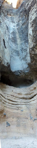
Sunday morning dawned cloudy and chill. We had decided we would take on the Mule Ears Spring hike. It is a 3.8 mile round trip with a net elevation gain of 20 feet. However that NET does not give notice of several lengthy steep elevation changes along the way. We were still layered and had settled into hiking mode as we set out. Before we got there we passed Burro Spring Pour Off and the short trail was too tempting so we stopped and hiked into this box canyon to see the waterfall that you don’t want to see if there is water coming down. The canyon is a trap, once water starts flowing it will fill and there is no place to escape the flood.
All was dry!
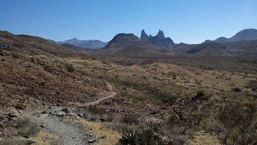
Mule Ears gets its name legitimately, here is what it looks like from the trail:
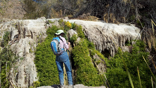
We continued on to our target and began the hike into a spring that flows in the desert. We made one stop to shed layers and eat our lunch on the way in. We found the remains of the corral at a trail junction and followed around the wall to a short trail that lead to the spring which was flowing and had a population of frogs we could see and hear.
We concluded the day by continuing down the road to Santa Elena Canyon and hike to narrow of the canyon. This gap in the surrounding cliffs is cut by the Rio Grande River which is the border with Mexico at this point . It feels so narrow that it seems we could touch both sides at the same time. Although we had considered taking Old Maverick Road back to the main highway, the Volunteers had discouraged us and it would be dark by the time we got back to Gee 2 so we retraced our route and arrived at twilight.
Monday we decided to devote to the eastern end of the park, primarily Boquillas Canyon which defines the point at which the river departs Big Bend. We had explored this area thoroughly in 2005 when we last visited here, but felt it worth another trip in any event. The river is shallow and slow at this part of its course and there are many “informal” crossing points. These are used today by residents of Boquillas, on the Mexican side to set up little bodegas to sell their handcrafts.
They set them out on rocks with an honor jug and signs with prices. Purchases are discouraged by the Border Patrol and any goods bought this way are subject to confiscation. This does not seem to bother either sellers or buyers. We were carrying no money and thus avoided temptation.
After spending time along this beautiful canyon we retraced past the campground where we stopped for lunch and then went on to the Hot Spring. I put on a bathing suit and we walked in from the parking lot and met a small crowd seated in the remains of the hot spring house enjoying the spring. in 2005 the river was so high that the entire foundation was under water and it seemed dangerous to try to get on top of the vent. Now, with the river several feet lower, we could walk to the foundation and pick our way to a seat in the spring. Carol rolled up her slacks and joined me on the edge of the spring and we had a lively discussion with other travelers who had come to the spring.
This ended our time in Big Bend. In the morning we rolled out along the road to Study Butte and then we decided to take the road to Presidio. It was a lot of work driving this rollercoaster of a road in Gee2, but the scenery was well worth the 67 miles of extreme hills (15% grades) and tight turns. We stopped in Marfa long enough to pick up our mail and continued on to Sierra Blanca about which later.