A Slow Trip up the Blue Ridge Parkway
After a night just north of Cherokee, a place we really do not have the urge to revisit, we found our way to the Blue Ridge Parkway about 50 miles north of its southern end in The Great Smoky Mountains. We left behind the dramatic presentation Unto These Hills – a Dramatic Retelling of Cherokee History and Cades Cove and many wonderful hikes that will have to wait for another day, another trip. We had decided at some point to retrace a trip we had taken in 1984 with a tent and B and B guide but going northward, the direction of the Appalachian Trail through hikers, this time. Our first stop was Asheville, the home of The Biltmore, and many art galleries and wonderful scenery. Although I wanted to see The Biltmore again, we decided to focus on hiking, craft shopping and galleries.
Having done an exploratory drive up the Parkway to the closure and a nice hike we came back through Asheville to see if we could find Mast General Store to see if they could outfit me with hiking boots. We could not find parking and we were tired so we went back to Gee 2 for relaxation and dinner. The next day we set out to shop at the Allanstand Folk Art Center on the Parkway. It is one of five craft centers representing North Carolina crafters. After successful shopping there among some of the finest crafts we’ve seen we set out for Asheville again and this time we found parking. Before we could get to the store however we walked into Blue Spiral Gallery and were lost for over an hour. The space is immense, the collection superb and the people were very warm. It was now lunch time so we retraced steps to a spot we had noticed driving in called Mellow Mushroom where we had a delightful lunch on the street under the warm sun. The shopping at Mast General was less satisfying and I still have my 30 year old Danner hiking boots. Several galleries later including a wonderful new photography gallery left us ready for rest. After happy hour with neighbors in the campground we had a light dinner and some reading before falling asleep exhausted.
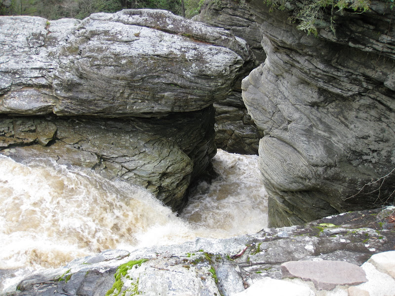
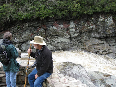
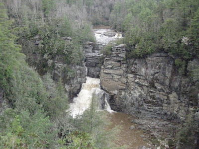
As we pulled out of Tapps RV in Asheville we knew we were facing a major detour around a large landslide about 15 miles north of us. We skipped the 50 miles, having explored the southern portion up to the slide area by car the day before. We began the journey using a wonderful book “Walking the Blue Ridge” by Leonard M. Adkins. We have had this book for a dozen years or more, but little changes on the Parkway. We had two problems. The book is laid out North to South so we felt like we reading Hebrew as we started with the book opening from the right (the back to English readers) and worked our way forward. This resulted in a number of surprises as we failed to leap ahead to the beginning of a section to read the background that we were traversing in reverse order. The other “problem” was the date. Very little (next to nothing) is open on the Parkway before May 1. This included campgrounds. I called the ranger desk and was told that Linville Falls and Peaks of Otter were the only two that were open. There is over 200 miles of ridgeline between them. Well 50% is better than nothing. We spent two lovely nights in Linville Falls CG with a couple of other RV’s and two Hosts. Even the water was not on, no problem for us as we bring our own, but for the hosts it was a very real issue. They are promised full hookups. We took a lovely hike to Linville Falls from the campground where we met and hiked with Dennis and Beth Bedell, the other motorhomers camped near us. They joined us for happy hour later that day after we went exploring in the car.
 |
| From Winter 09 Vol 2 |
 |
| From Winter 09 Vol 2 |
 |
| From Winter 09 Vol 2 |
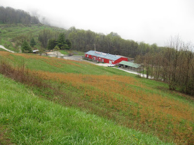
On the exploration we came across the Altapass Orchard.
 |
| From Winter 09 Vol 2 |
It was closed, but we saw activity and pulled in. We met the owner who has been running the orchard and retail store for 16 years. They have live local music on weekends and are working to preserve the orchard and its surroundings. The place was built by the railroad to generate freight for their new rail line. We were told that rail buffs will recognize the Clinchfield Loops as an amazing railroading achievement and it is still in use and visible from the orchard stand. We drove on and returned to Gee 2 eventually.
The next morning, with Carol at the helm, we continued north. Our major stop was at the Moses Cone Manor House. The weather was not friendly and it was snowing as we pulled into the parking lot. The Manor sits on a large estate that was given to the Parkway. It comprises the house and miles of carriage trails overlooking Blowing Rock. The manor house is another of the Craft Guild chain and the material on display is just wonderful. Fortunately we are space limited in the motorhome and are very much in “look, don’t buy” mode. We sat in the coach with the dining table overlooking the valley while we enjoyed our lunch and the view. Along the way we stopped in more overlooks and roadside pull offs than it is reasonable to record. Many of these stops for just a few minutes so the driver could take time to see and enjoy the scenery. Our stop for the night was in the town of Meadows of Dan, Virginia, at the Meadows of Dan Campground. It seemed familiar and it was. We had stayed there in 2003 when we joined Dan’s family for the Floyd Fest music festival along the BRP nearby.
Our plan for the following day was to camp at Peaks of Otter and continue our exploration of that area. We have stayed there twice before, once in a tent many years ago. It is a beautiful place with a lodge across the lake from the campground and a trip to Sharp Top that can be hiked or for a small charge there is a bus to the top. Actually one year we climbed another peak and were almost to the bottom before Carol missed her camera. We ran back to the top and it was gone. We stopped at the ranger station to report it and he already had it and was holding it for us. There are also many engaging level walks in the area. Our stop was not to be this time. It was still closed! I called to ask if we might stay over in the picnic area, but the ranger said that the enforcement division would not be happy. We got out the books and settled on Yogi Bear Jellystone RV Resort in Natural Bridge. The only reason we stayed there was that the alternative was a KOA that cost more and had nothing more to offer that we wanted. Germain, the GPS, said we should continue north a bit a then turn left on Petites Gap road for the best route to the campground. We verified that the GPS was set to AVOID unpaved roads. As I turned left over Carol’s well stated qualms I said “see the road is paved” for the first 100 yards! We entered a roughly 3,000 foot descent in 5 miles on a road that was single track dirt with occasional turnouts for vehicles to pass. Since we are used to the road to Dan and Malena’s I was most concerned about the tightness of the hairpins and the steepness of the descent. The turns were fine, if a bit scary, and the descent was first gear and foot on the brakes all the way down. We met three cars coming up and were fortunate that they could see us in time to pull off and let us pass. We would stay at this campground again if necessary as we have once before. We would not enjoy it in season as it clearly caters to families with noisy children and has many wonderful attractions for them.
Thursday found us on our last lap on the Parkway as we climbed up route 501 to rejoin the Parkway at its lowest point crossing the James River where it crosses the Blue Ridge, this is 649 feet. The highest elevation in Virginia is 10 miles to the south at 3,950, we did most of this descent on the aforementioned dirt road! We stopped at the river crossing to enjoy the trails that reach the river’s edge and pass under the BRP bridge as it crosses the river.
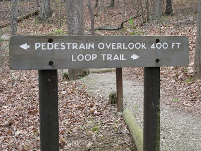
Some spelling errors are easier to correct than others:
 |
| From Winter 09 Vol 2 |
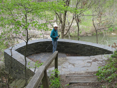
and here is the Pedestrain at the Pedestrain Overlook.
 |
| From Winter 09 Vol 2 |
We made one more stop that day at Indian Gap for a very short hike, about.3 mile round trip, to a wonderful jumble of immense boulders that would be a wonderful playground for children of most ages. After a lunch stop in a pull out overlooking Sherando Lake I took the helm and we began a familiar drive that brought us to Dan and Malena’s early afternoon.
We are here until Sunday, May 3 and then we will try to make the 500 miles to Rochester in one day, unless we take two.
<
 |
| From Winter 09 Vol 2 |
Mast General Store is definitely my first stop when I visit Asheville or the surrounding WNC areas!